A run not to be missed. The Moorfoots. Where are they? Look south from Arthur's
Seat, down the valley towards Penicuik - Pentlands on your right, over
on the left are the higher Moorfoots. When John's (JBF) email arrived to do the annual
pre-dinner run (without the dinner), some of us (i.e. me) thought, nice outing.
Arriving at Gladhouse on Saturday morning, only ten runners - obviously they knew
something I didn't!
We took a direct line up Jeffries Corse and thence to Dundreich (622 m). Oz and I
thought this was a trad horseshoe, and inclined towards Bowbeat Hill, now covered in
wind turbines, while the others shot down to the Long Cleave. According to Keith, the
summit route here is awful, in the end we followed the others to the valley at the
Cleave. Here we waved goodbye to Willie and crew, and after a sharp up
to Blackhope Scar (651) Shane and Louise headed off. Numbers falling precipitously,
a slightly mad core group elected to do the full monty before anyone could change
their mind. Next, the long run down over Garvald Law, after reaching the Hope Burn
a 45 degree traverse steep right up (a most unusual route; JBF pointing left
while Keith ascended right). Over to Windy Slack, and then an interesting
'path' possibly an old drove road, up to the gate not far from Torfichen
Hill, with superb views over the Gladhouse reservoir to Carnethy in the distance.
From here, a bit of endurance. Karl, Oz and Alan sped off while I stuck
to JBF's heels (good strategy, John holds the circuit record) along the
long mire via Mauldsie Hill (513) and, just around the Kips, cut right down towards
Gladhouse. Here the front runners encountered a young deer caught in a mean snare-trap.
By the time John and I arrived the others had succeeded
in releasing the poor beast which promptly bounded away over the hill
without too much evidence of lasting damage! Speedy descent to Moorfoot
Village, pausing at the ruin of Hirendean Castle
(Heringdean, c. 1610; Heeringlon Kirk c. 1750), an old dun. Keith and I
discussed the dating of the dry valley walls on the return to Gladhouse.
This 16 mile / 1000 m circuit
is wonderfully wild terrain, a tough run, harder than the Pentland
Skyline (though a similar length) but in some ways more rewarding.
All of it, almost, is 'off track', eternal heather-hopping, with
a pay-off between the delights of running free down steep soggy
slopes and the dreaded tussocks. Keith, an aficionado of glutinous
lumps, rates the tussocks on Huntly Cot as the worst in Scotland
- ankle-crunching and knee-wrenching horrors. At least one runner
in front disappeared into the morass, to emerge kicking and spitting
the local peat. A great day's run, thanks John!
RL
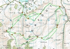
It has been pointed out that the route
varies markedly. Variations on the optimum line for the Moorfoot "Skyline" (see
Keith's map) have been vigorously promoted over the years, he would welcome
comments and insights!
|
)
)
)
)
)
)